×
Redding, California
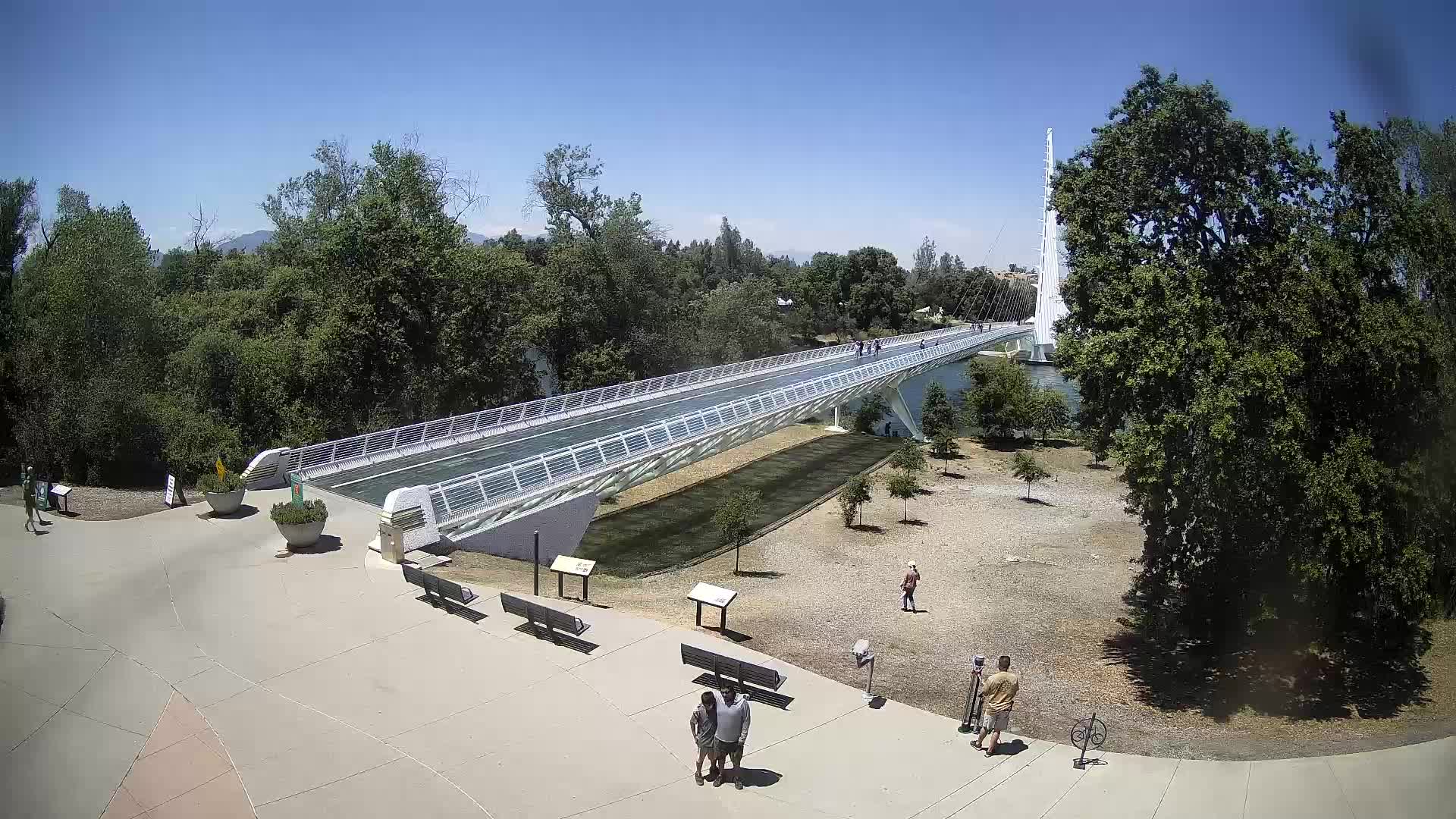
"Where architecture meets astronomy — a 218-foot cable-stayed bridge that doubles as the world's largest sundial."
↓ Scroll to explore
From vision to reality — the complete story of how the Sundial Bridge came to span the Sacramento River.
Photo by: [Photographer Name]
Source: [URL or Wikimedia Commons Link]
License: [CC BY-SA 4.0 / Public Domain / etc.]
The concept for a pedestrian bridge in Redding was born from a city initiative to revitalize downtown and create a connection between the civic center and the Sacramento River Trail. The city of Redding sought to build a landmark structure that would serve both as functional infrastructure and a work of public art. The idea was to create a bridge that celebrated Redding's unique position — one of the sunniest cities in California, with an average of 257 sunny days per year.
World-renowned Spanish architect, sculptor, and engineer Santiago Calatrava was chosen to design the bridge. Calatrava is famous for his sweeping, organic architectural forms inspired by nature and the human body. His studio in Zurich, Switzerland, was selected through a competitive international design competition. Calatrava's design featured a dramatic tilted tower that would serve as both a structural support and the gnomon (the shadow-casting part) of a giant sundial.
The bridge site was selected at the confluence of the Sacramento River and the downtown area of Redding, specifically connecting the city's civic center on the east bank to the Sundial Bridge Trailhead on the west bank. The location was chosen for its panoramic views of the Shasta-Trinity National Forest and the Cascade Mountains, including the iconic Mount Shasta on clear days. The site sits at approximately 40.5865° N latitude, which directly influenced the angle of the tower.
Construction commenced in 2002 with the primary contractor being Clark Construction Group (now Clark Construction), a major national construction firm. The engineering was a collaboration between Calatrava's team and structural engineer John A. Martin & Associates (now part of Ramboll). The bridge's most striking feature — the 218-foot-tall tilted concrete tower — required innovative engineering to achieve its precise 42-degree lean, which corresponds to the latitude of Redding.
The Sundial Bridge was completed in 2004, taking approximately 2 years from groundbreaking to dedication. The bridge was officially dedicated on October 2, 2004, with a ceremony attended by Santiago Calatrava and city officials. The total construction cost was approximately $2.5 million, funded through a combination of city bonds, state grants, and private donations from the community.
Photo by: [Photographer Name]
Source: [URL or Wikimedia Commons Link]
License: [CC BY-SA 4.0 / Public Domain / etc.]
Essential details about the bridge's design, construction, and the materials that make it possible.
The bridge spans 218 feet (66.4 meters) across the Sacramento River. The entire structure, including the plaza and approaches, extends approximately 360 feet in total length.
The iconic tilted tower rises 218 feet (66.4 m) above the river. It leans at precisely 42 degrees from vertical — matching the latitude of Redding, California.
Construction took approximately 2 years (2002–2004). The tower alone took several months to engineer and pour, requiring specialized concrete techniques for the tilt.
The bridge cost approximately $2.5 million to build. Funding came from city bonds, state transportation grants, and private community donations.
The tower casts a shadow onto a sundial face embedded in the plaza on the east bank. The shadow indicates the apparent solar time. The plaza also features hour markers and minute indicators.
A cable-stayed pedestrian bridge with a single inclined tower. The tower is anchored on the east bank, and cables extend from the tower to support the bridge deck on both sides.
What the bridge is made of, where the materials came from, and how they were fabricated.
Photo by: [Photographer Name]
Source: [URL or Wikimedia Commons Link]
License: [CC BY-SA 4.0 / Public Domain / etc.]
| Material | Quantity / Specification | Supplier / Manufacturer | Purpose |
|---|---|---|---|
| Reinforced Concrete | ~3,200 cubic yards | Central Valley Concrete (local supplier) | Tower structure and foundation piers. The tower's hollow concrete shaft was poured in stages with internal post-tensioning tendons. |
| Steel (Structural) | ~180 tons | Steel Dynamics, Inc. / local fabricators | Cable anchorages, tower cap, and internal structural reinforcement. Custom-fabricated steel nodes connect cables to the tower. |
| Post-Tensioning Cables | ~4,500 linear feet | Freese and Nichols (engineering) / Dywidag Systems | High-strength steel strands that post-tension the concrete tower, providing the structural integrity needed for the 42° lean. |
| Stainless Steel Cables | ~21 pairs (42 cables total) | W.S. Tyler / Martinrea International | Cable-stayed support system. Each pair of cables fans out from the tower to the bridge deck, providing lateral and vertical support. |
| Bridge Deck (Concrete) | ~800 cubic yards | Central Valley Concrete | Reinforced concrete deck with a thin steel plate overlay for pedestrian surface. Width is approximately 10 feet. |
| Granite / Stone | ~200 tons | Local California quarries (Shasta County) | Sundial plaza face, approach walkways, and retaining walls. The sundial face itself is precision-cut granite. |
| Stainless Steel (Sundial Face) | ~500 sq ft | Custom metal fabrication shop (Pacific Northwest) | The sundial dial plate with engraved hour and minute markers. The gnomon shadow falls on this calibrated surface. |
| Fundation Piles | ~120 linear feet depth | Local piling contractor | Steel H-piles driven deep into the riverbed to anchor the tower foundation, reaching stable bedrock layers beneath the Sacramento River alluvium. |
Photo by: [Photographer Name]
Source: [URL or Wikimedia Commons Link]
License: [CC BY-SA 4.0 / Public Domain / etc.]
The technical achievements that made this bridge possible.
The tower foundation required deep-driven steel H-piles reaching approximately 120 feet below the riverbed to reach stable bedrock. The foundation was constructed using a cofferdam to keep the Sacramento River water out during construction.
The tower uses an internal post-tensioning system with high-strength steel tendons running vertically through the hollow concrete shaft. This system allows the tower to lean at 42° while maintaining structural stability under wind and seismic loads.
Located in Seismic Zone 4, the bridge was designed to withstand earthquakes up to magnitude 7.5. The flexible cable-stayed system allows the bridge to sway, dissipating seismic energy. The foundation piles extend into stable bedrock layers.
The sundial is calibrated for Redding's latitude (40.5865° N). It shows apparent solar time, which differs from clock time by up to 16 minutes due to the equation of time. The bridge accounts for the Pacific Time Zone offset and daylight saving adjustments.
The tower and cables were engineered to withstand wind loads up to 110 mph. Wind tunnel testing was conducted during the design phase. The open cable arrangement minimizes wind resistance and vortex shedding.
The tower was constructed with a tolerance of ±1/8 inch for the tilt angle. The sundial face was precision-graded to within arc-minute accuracy. The cable lengths were individually calculated and factory-fabricated.
Plan your visit to the Sundial Bridge or get in touch with questions.
Photo by: [Photographer Name]
Source: [URL or Wikimedia Commons Link]
License: [CC BY-SA 4.0 / Public Domain / etc.]
Sundial Bridge Trailhead
100 Bridge Way
Redding, CA 96003
Open daily
Dawn to Dusk
Free admission
City of Redding
Parks & Recreation Dept.
info@redding.org
City Hall:
(530) 245-6200
Trailhead Info:
(530) 247-5900